
How Dutch Media Got It Wrong on Von der Leyen’s GPS Incident
When the Financial Times (FT) published a story on September 1, 2025, about GPS jamming affecting the plane of European Commission president Ursula von der Leyen, many Dutch newsrooms followed suit. But in doing so, they repeated serious inaccuracies—without fact-checking.
Update; September 2, 2025 23:20. The Financial Times journalist who wrote the story with three factual errors in it was onboard the aircraft. Didn’t ask Henry Foy the pilots of the airport what navigation aids they used instead of GPS?
The FT suggested that the pilots were forced to land using paper maps after GPS navigation failed during the approach to Plovdiv, Bulgaria. Within hours, Dutch outlets from NOS to AD and De Telegraaf echoed this account. The problem? The story wasn’t true.
This article shows that the aircraft experienced GPS interference, but it did not require paper charts and did not circle the airport for an hour. Instead, it used an alternative electronic navigation system to land. The article is not conducting an investigation, nor does it confirm that Russia was behind the GPS interference. What is certain, however, is that GPS disruption is widespread in this region.
The author of this article has focused on the Dutch media. Media in other countries also widely repeated the errors in the Financial Times’ reporting. For example, CNN wrote: “The plane landed safely, the European Commission spokesperson said. A source familiar with the situation told CNN the pilots landed the plane using paper maps.”
An example of errors by Germany media is Tagesschau. Tagesschau is Germany’s most well-known and longest-running television news program. It is produced by ARD-aktuell, the central news department of ARD (the German public broadcasting consortium). It wrote ; “Ein Flugzeug mit EU-Kommissionspräsidentin von der Leyen an Bord ist vor der Landung in Bulgarien von einer GPS-Störung betroffen gewesen. Der Pilot landete mithilfe analoger Karten. ” Analoger Karten means ‘ paper maps’. Franch Le Figaro also copied the errors by FT.
Origins of the Error
At around 11:00 a.m. Dutch time, the FT published its article containing the following claims:
“A suspected Russian interference attack targeting Ursula von der Leyen disabled GPS navigation services at a Bulgarian airport and forced the European Commission president’s plane to land using paper maps.
A jet carrying von der Leyen to Plovdiv on Sunday afternoon was deprived of electronic navigational aids. After circling the airport for an hour, the plane’s pilot took the decision to land manually using analogue maps, they added.”
Even after an update later in the day, these errors remained. A simple check via flight-tracking website Flightradar24 could have disproven the narrative. The aircraft—a Belgian-registered Dassault Falcon 900 (OO-GPE)—was the only business jet landing at Plovdiv on August 31. Its track log shows no evidence of circling for an hour.
Why the FT had this information became clear on September 2. Henry Foy, the Financial Times Brussels Bureau Chief, was in fact on board the aircraft. He states this in this article based on an automated translation of this interview.
He says: And on the approach to Plovdiv, we lost altitude. We came down preparing for landing, and then all of us on board realised that we were circling the airport. We had been for a while. We were way past the planned landing time.
Any aviation expert could also have explained that GPS is not the sole means of navigation and that paper maps were not needed.
The Chain Reaction
Despite the availability of easy verification, Dutch media rushed to publish. One reason: news agency ANP repeated the FT account, which many Dutch outlets routinely adopt without additional checks.
Examples included:
- Algemeen Dagblad (11:51): Reported that von der Leyen’s plane circled for an hour and landed “using analogue charts.”
- NOS (13:11): Claimed the pilot “had to land without electronic navigation, via physical maps.”
- NRC (12:27): Wrote that the aircraft landed “in an old-fashioned way: by using paper maps.”
- NU.nl (12:32), Telegraaf (12:34), Volkskrant (12:43), RTL Nieuws (~14:00): All repeated the same storyline almost verbatim.
One exception was Het Parool (19:45), which reported that the crew used “other navigation instruments” and mentioned the Instrument Landing System (ILS)—closer to the truth.
What Actually Happened
Flightradar24 replay data shows the Falcon 900 approaching from the northwest, making a series of course changes before lining up for runway 30. At no point did it circle the airport for an hour.
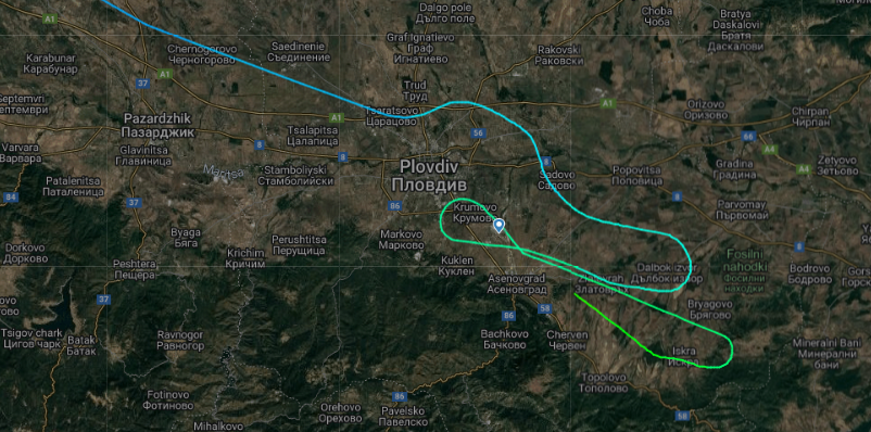
More importantly, cockpit-ATC communications recorded by LiveATC.net reveal that:
- At 14:05 UTC, the pilot accepted instructions for an RNP (GPS-based) approach to runway 30.
- At 14:10:50, the pilot reported GPS issues and requested radar vectors. ATC responded that radar service was unavailable.
- The crew then requested to fly to the PDV VOR beacon to set up an ILS approach—using ground-based navigation aids independent of GPS.
[soundcloud url=”https://api.soundcloud.com/tracks/2163376323″ params=”color=#ff5500&auto_play=false&hide_related=false&show_comments=true&show_user=true&show_reposts=false&show_teaser=true&visual=true” width=”100%” height=”300″ iframe=”true” /]
In short: the pilots did not resort to paper maps. They switched to standard radio-based navigation systems (VOR and ILS), which remain common backup procedures worldwide.
[soundcloud url=”https://api.soundcloud.com/tracks/2163382173″ params=”color=#ff5500&auto_play=false&hide_related=false&show_comments=true&show_user=true&show_reposts=false&show_teaser=true&visual=true” width=”100%” height=”300″ iframe=”true” /]
Two audio fragments of the communication between one of the pilots and air traffic control show that indeed the aircraft had GPS issues. However no need for paper maps. The crew used the VOR and ILS radio signals to navigate and land.
After landing one of the pilots thanked air traffic control for the help. He told the flight had “GPS issues and had to proceed conventional. ” Listen to that part here. Conventional is the VOR/DMA and ILS.
As LiveATC deletes recordings after seven days, this is the URL of the ATC communication Plovdiv approach and tower at August 31 between 14:00 and 14:30 UTC.
The communication between 14:30 and 15:00 can be listened to here. After landing one of the pilots again states he had to use the VOR and ILS instead of GPS navigation because of issues with GPS.
Official Clarification
The Bulgarian News Agency (BTA) quickly issued a statement from the country’s Government Information Service:
“In order to ensure the safety of the flight, the Bulgarian Air Traffic Services Authority immediately proposed an alternative landing method using ground-based navigation aids (instrument landing).
These ground-based systems are independent of GPS and enable a safe and reliable landing.”
Conclusion
The FT’s original misreporting cascaded through ANP and into much of the Dutch press, where outlets repeated the claim without verification. The reality, confirmed by flight data and ATC audio, is that the crew relied on standard electronic navigation tools, not paper maps.
The episode underscores a broader issue: in the race to publish, fact-checking—even on technical matters easily verifiable with public tools—was abandoned. And when agencies like ANP replicate an error, the entire media ecosystem risks amplifying misinformation.